WASHOE COUNTY EMERGENCY MANAGEMENT: AVALANCHE HAZARD ADVISORY FOR CRYSTAL BAY & THIRD CREEK
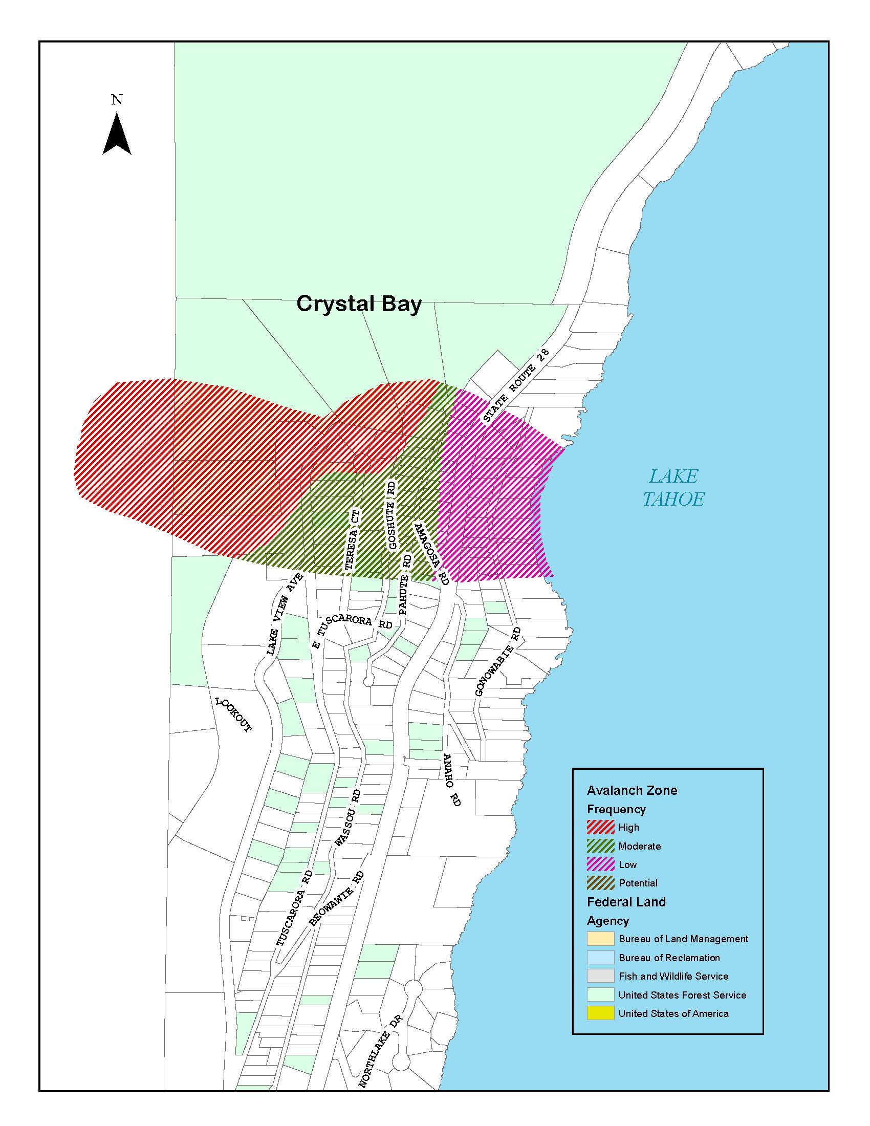
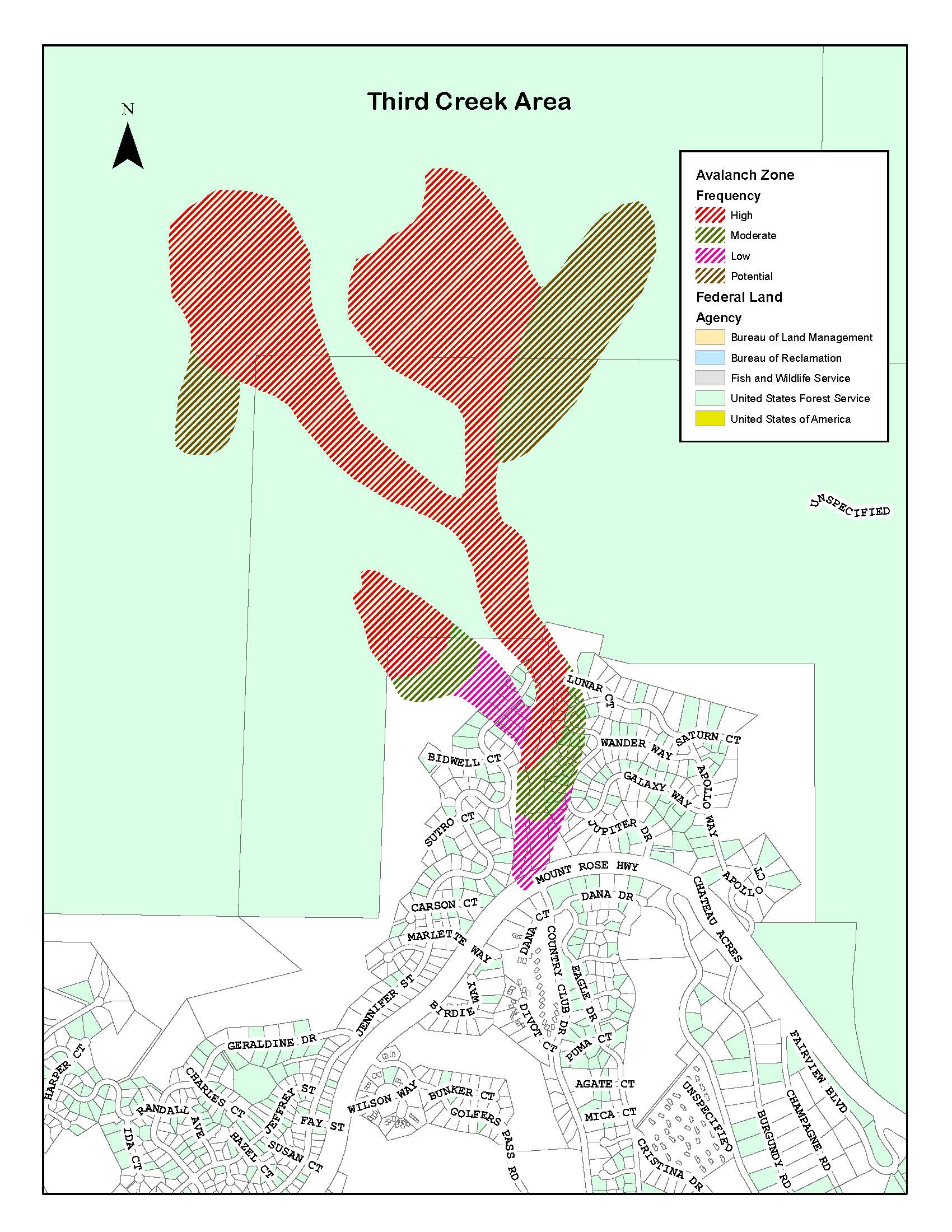
The following is a slope-specific avalanche danger forecast for the avalanche terrain above Lakeview Ave, Tuscarora Rd, and Teresa Ct in Crystal Bay, Nevada; and the terrain above upper Jennifer St, Sutro, Bidwell, Lunar, and Mercury Courts in the Third Creek drainage (below Rose Knob Peak and environs) in Incline Village, Nevada. This danger forecast is intended for use by residents and motorists and may differ considerably from the general backcountry avalanche forecast. This forecast is not intended as a resource or risk management tool for backcountry travelers. Backcountry travelers are strongly advised to refrain from any activity on or around these slopes. Activity on these slopes could subject residents, motorists, and infrastructure below to serious danger.
Avalanche information for Lake Tahoe backcountry travelers can be found at sierraavalanchecenter.org.
Crystal Bay
3-CONSIDERABLE AVALANCHE DANGER
The past 18 hours has deposited enough snow above Crystal Bay to bury many slope anchors. Though today’s daytime snowfall has been less than forecasted, the next 36 hours is still predicted to deposit substantial new snow—with strong winds. If this forecast holds true, avalanche hazard will increase significantly overnight and into tomorrow. Large snowfall events can mean impassable roads, power outages, and problematic communication and emergency response. This advisory is a reminder to remain diligent. An avalanche of virtually any size is large compared to a human, and they all can produce significant forces, especially in confined or complex terrain. It is advised to refrain from any unnecessary outdoor activity on, under, or around the steep snow-covered terrain in Crystal Bay. Additional avalanche advisories will be issued as conditions change throughout the next couple of days.
Third Creek
New snow in the upper Third Creek drainage will accumulate on a relatively hard, smooth, old snow surface. Avalanche danger is forecast to be HIGH in the upper watershed; avalanche size and speed can be significant. The bottom of many of these avalanche paths terminate in steep-sided and confining terrain that concentrates the forces of flowing snow. This is dangerous avalanche terrain that presents a substantial risk.
Residents and motorists are advised to refrain from all outdoor activities in these areas. Residents who remain in the neighborhoods may risk exposure to avalanche. For immediate emergency shelter needs, please contact the American Red Cross Disaster Services hotline at 855-891-7325.
North American Public Avalanche Danger Scale
1-Low Avalanche Danger
Generally safe avalanche conditions exist. Natural avalanche release is unlikely. Any avalanche that does release will not have the size or speed to impact residents or roads.
2-Moderate Avalanche Danger
Heightened avalanche conditions exist. Natural avalanche release is unlikely. However, small changes in snowpack strength or stress could lead to avalanche release. It is unlikely these avalanches could impact residents or roads.
3-Considerable Avalanche Danger
Dangerous avalanche conditions exist. Natural avalanche release is possible. Any avalanche released will have the potential to impact residents and roads. These avalanches can cause serious injury or death and property damage.
4-High Avalanche Danger
Very dangerous avalanche conditions exist. Natural avalanche release is likely. These avalanches will impact residents and roads and may be large and destructive. These avalanches can cause serious injury or death and property damage.
5-Extreme Avalanche Danger
Very dangerous avalanche conditions exist. Natural avalanche release is certain. These avalanches will impact residents and roads and may be very large and destructive. These avalanches can cause serious injury or death and property damage.
###

